Sri Muda flood tragedy: From an engineer's perspective
Sri Muda was developed near the Klang River with a maximum height of 1.5 meters from the sea level.


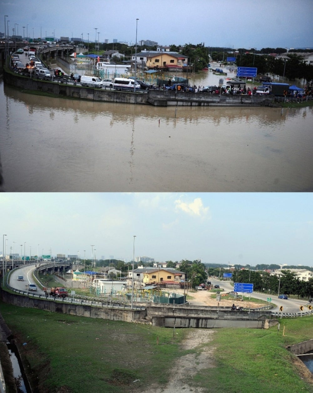

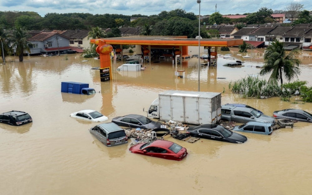
SHAH ALAM - It has been three months since the flood tragedy which hit several areas in the Klang Valley with Taman Sri Muda being among the worse place affected by the flood disaster.
A myriad of theories and debates have been put forward as to how Sri Muda had 'drowned' in a blink of an eye
It is undeniable that the incessant rainfall in the country was among the main factors which caused the floods.
However, according to professional engineer Datuk Ir Hanapi Mohamad Noor, there were several other factors that contributed to the tragedy.
Hanapi explained that originally, Sri Muda was developed on a low topographical land area next to the Klang River which was suitable to be made as a floodplain with its ground level at only between 1 and 1.5 metres above the average sea level.
“Although there were developments on the site, it was not more than 3 meters above the average sea level and the previous flood level has reached 4 metres,” he told Sinar Harian.
It means that if heavy rains and water levels in Klang Valley exceeded 3 metres, Taman Sri Muda will be flooded.
Hanapi who is also the vice president of the Water Resources Management and Hydrology Division, added that the water flow from the Klang River located in Taman Sri Muda came from a wide catchment area of more than 1,110 square kilometres which covers the Hulu Klang, Batu, Gombak, Ampang, Kerayong and Damansara areas.
“With the construction of the Klang Gates Dam in 1958 and the Batu Dam in 1984, it is estimated that more than 10 per cent of the water flow that previously flowed directly into the Klang River from the catchment area managed to be collected.
“However, on Dec 18, last year, some of the water from both dams have been released because they had surpassed the danger level.
"The additional flow from the Batu and Klang Gates dams had also contributed to the increase of the water flow in the Klang River in Taman Sri Muda," he added.
In addition, the high-tide phenomenon that occurred in December, last year, had caused a collision between the water flow from the Klang River catchment area and the tidal current from the sea.
He added that to develop low -lying areas such as Taman Sri Muda with housing projects, land reclamation works needed to be done at a level higher than 4 metres and higher than the previous flood level record and this of course, required high development costs.
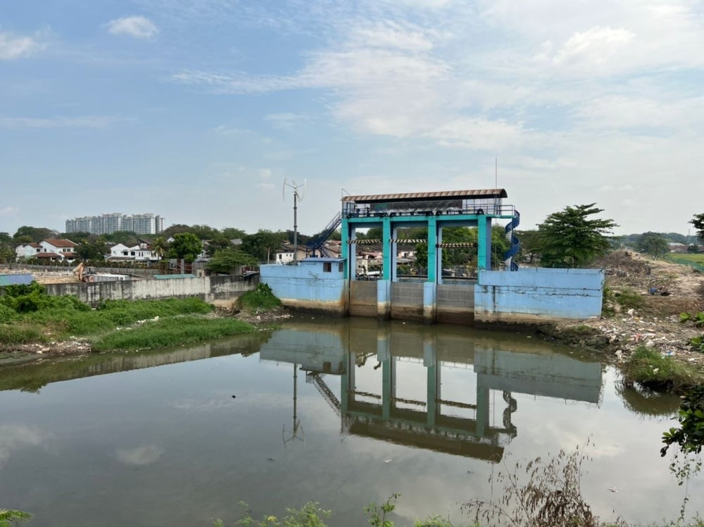
If the development level is not high enough, it will require additional infrastructure that can prevent floods such as large reservoirs, sluices, high capacity water pumps, raising the riverbanks, and develop an efficient internal drainage system.
According to him, after the floods in Sri Muda in 1995, the government through the Department of Irrigation and Drainage (DID) established flood mitigation projects involving the construction of river embankments, reservoirs, sluices and pumps.
“However, the flood prevention infrastructure that was built a few years after the massive floods in 1995 was designed for floods with a recurrence period of less than 100 years.
“For example, the riverbank has been raised with the construction of river embankments to an average level of 5 metres above the previous flood level.
“Checks by the DID on the flood incident record did not show any major flood incidents except for flash floods caused by local drainage problems until the Dec 18 incident, last year," he said.
Download Sinar Daily application.Click Here!