Baling's Sungai Kupang floods not man-made


SHAH ALAM - Contrary to the popular contention, the devastating flash floods which inundated a village in Baling recently is not a man-made disaster.
Instead, the Energy and Natural Resources Ministry classified it as a ‘geological phenomenon’.
In a report by its Special Taskforce, the cause of the disaster was said to have been due to a concoction of heavy rainfalls and massive landslides at the nearby mountains.
The report claimed that the cause of the incident was due to a rare geological phenomenon called debris flow, which also occurred in Sungai Lubok Panjang, Jerai and Sungai Lui, Hulu Langat as well as Sungai Telemung, Bentong, last year.
It reported that due to the active erosion in the Compartment 8 of forest reserve at Gunung Inas, the high silt content significantly amplified the impact.
“In this incident, more than 276,038 cubic metres of landslide material mixed with water which is abundant, flows along the river channel, and is capable of eroding the bottom and banks and flowing with 2,589,021 cubic metres of debris.
“As the amount of water increases, the flow phenomenon turns into a debris flood containing 3,275,467 cubic metres of debris and then 1,111,187 cubic metres of silt debris in the mud flood.
“A total of 7,251,704 cubic metres of debris was the main cause of the high power disaster,” it said in the report.
In addition, the report also included suggestions on follow-up actions that should be considered by the authorities for the people in Baling.
It recommended for a short term action, in which detailed mapping of debris flood geological disasters in Sungai Kupang be carried out within six months after the incident to collect data for follow-up action planning to reduce risk to the community.
It also suggested to introduce the Geological Investigation and Geoscience Bill to help replace the Geological Investigation Act 1974, which enshrines additional core areas related to Forensic Geological Investigation activities, Geological Disasters, Geoscience Research and development, and related enforcement areas.
“The main cause of siltation and additional factors of debris flood disasters are the opening of forest farms in the mountains or hilly areas.
“The government needs to take immediate action on whether this project should continue or take drastic action to transform it back into protected forest.
“If the plantation forest was to be maintained, then a follow-up action must be taken and improvement of the existing guidelines needs to be introduced to minimise the rate of erosion and avoid the tragedy of debris floods from repeating,” the report stated.
As for the long-term solution, it suggested for a National Geological Disaster Research Centre to be established to act as the front line of investigation when a geological disaster occurs in Malaysia.
The report also stated that the national geological disaster risk mapping programme in regards to the debris flows should be established, as well as initiating a network of early warning systems related to geological disasters at mountains.
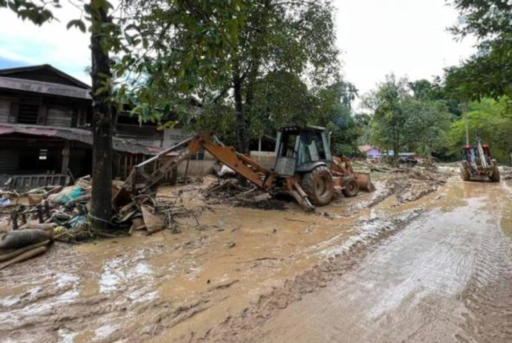
On July 4, a geological disaster that occured in Sungai Kupang in Baling at Kedah has resulted in three deaths, 17 houses destroyed, 3,546 residents affected, and losses estimated at RM25.91 million.
It was reported that heavy rains in the highland area of Gunung Inas has triggered multiple of landslides simultaneously, followed by the debris flow phenomenon in four main river branches, which ended with the tragedy of debris floods and mud floods in the area of the lowlands, namely Kampung Iboi and dozens of downstream villages.
Download Sinar Daily application.Click Here!


